Ascent – 2661 ft.
Descent – 2664 ft.
Min Elevation – 6038 ft.
Max Elevation – 8322 ft.
High Resolution Topo Maps
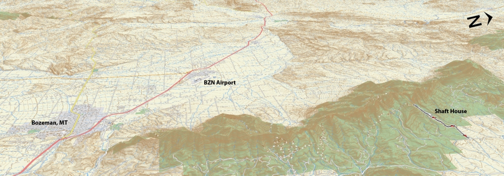
This trail is located on the northern end of the Bridgers (eastside). It is accessed by driving through Bridger Canyon and into the flats. The trail begins at the end of a dirt road and the parking lot has not been maintained and could easily be overlooked if you were not paying attention. Leaving the parking lot, you travel through tall grass that lines the trail for a good ½ mile and turns to a mix of meadows sprinkled with trees as you approach the Bridger Mountain Range. “Please stay on the trail as you will have to pass through private property
and a gate (please close the gate behind you)”. The trail quickly goes from a fairly mellow incline to a steep climb littered with loose rock. It does not let up on either the grade nor difficulty all the way to the top. With that being said, this is a difficult trail in both aspects as bike skills and fitness level. Your efforts do not go unnoticed as you will be greeted with a great view of a high mountain lake (Frazer Creek feeds this lake) about 3.8 miles up and then again once you summit at 4.5 miles. Once at the summit you have the option to continue down the opposite side towards Fairy Lake and wrap back on a logging road that will reconnect with Shaft House trail about 2 miles from the trailhead.
Driving Directions:
Drive approximately 28 miles from downtown Bozeman on Hwy. 86 to Seitz Rd. Turn left and continue down Seitz Rd which is a well-graded gravel road. Drive 2.5 miles to the parking lot (it is straight ahead and is currently poorly marked). You’ll see singletrack emerging from the south near the fence line. This is the Shafthouse Trail #540.
To set up a shuttle, leave one vehicle at Shafthouse Trail #540, drive 4.7 miles back to Fairy Lake Rd. Drive about 5.5 miles up the washboarded, rocky road until you reach an open meadow with a small parking area on your left. The trailhead is marked by a sign on your right just beyond the parking area. The singletrack climbs about 1,000 feet, reaching the ridgeline in little less than a mile. Follow the ridge north until the trail begins to descend. Stop here for a quick picture, water, and to armor up—it will give you a great perspective of what lies ahead. You should be able to make out your shuttle vehicle 4.5 miles away and 2,000 feet down.
Google Maps Driving Directions (IOS and Android compatible)
Shaft House Trailhead


