Trail Difficulty – Intermediate
Trail Length – 19.2 miles
Trail Time Share – No
Ride Type: Loop / Shuttle
Ascent – 2821 ft.
Descent – 2819 ft.
Min Elevation – 5270 ft.
Max Elevation – 6936 ft.
High Resolution Topo Maps
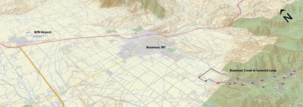
This is the beginning of the Mystic Lake trail that ends at the bridge 4.7 miles up from the parking lot. This is an old logging road that is still maintained and groomed for cross country skiing in the winter. This is a great trail for intermediates and up who are looking for a longer ride while still mostly sticking to old logging roads. Starting at the Sourdough Canyon parking lot it is fairly level for the first ½ mile then gradually begins to climb all the way to the bridge. The creek that runs year-round has numerous locations to stop and take in the sounds and scenery. Once you reach the bridge you will cross over it as if you were going to continue up towards Mystic Lake. Rather than continuing up and around the hairpin turn right after the bridge you will continue straight on a less traveled logging road. You will follow this logging road (don’t take any spur/singletrack trails). The logging road (FS 1761 makes its way to the gate at the top of Moser Creek, about 4 miles from the bridge. Once you reach the gate, go through it and turn right onto Moser Creek logging road. Ride along this road as it skirts its way around the mountain side with views of Bozeman Creek below. Keep your eyes out for a small singletrack off the right (2.60 miles) from the gate. This is where you connect to the top of Leverich Canyon. Shortly after riding on the singletrack you will come upon a junction (go left, this is the recommended direction of travel). One more punchy climb and you will be at the top of Leverich Canyon and prepare for a screaming fun downhill! Ride the trail all the way down past the trailhead and continue on S. 3rd till you reach Nash Rd. Take a right on to Nash and this will connect you back to Sourdough Canyon Rd (Bozeman Creek Trailhead).
Driving Directions:
Departing from Main street in downtown, take South Church Avenue (this will become Sourdough road after crossing Kagy) heading south, turn right on Nash Road (only direction that remains paved) and continue a short distance before turning left on Sourdough Canyon Road (large rectangular sign on side of road). Follow Sourdough Canyon Road until you reach the trailhead at the end of the road.
Google Maps Driving Directions (IOS and Android compatible)
Bozeman Creek / Sourdough Canyon


